Update: Highway 97 is reduced to single lane alternating traffic with a pilot car in place between Highway 24 and Big Bar, following increased fire activity from the Flat Lake fire Tuesday evening.
A BC Wildfire official confirmed Wednesday morning that the fire had “advanced to the highway at 83 Mile” and that structural protection units and local volunteer fire departments were brought in to fight.
Officials are reporting that some spots did cross the highway, however, crews that were on sight were able to extinguish and continue patrolling the west side.
Today crews will be working to secure the area at 83 Mile and Highway 97, north of Bullock Lake Road and towards Davis Lake. Strucural protection personnel will carry out patrols along the transmission line and heavy equipment will work to secure the area near Storm Road north to the 3000 road, as well as work on a guard from Gustafsen Lake connecting existing road systems.
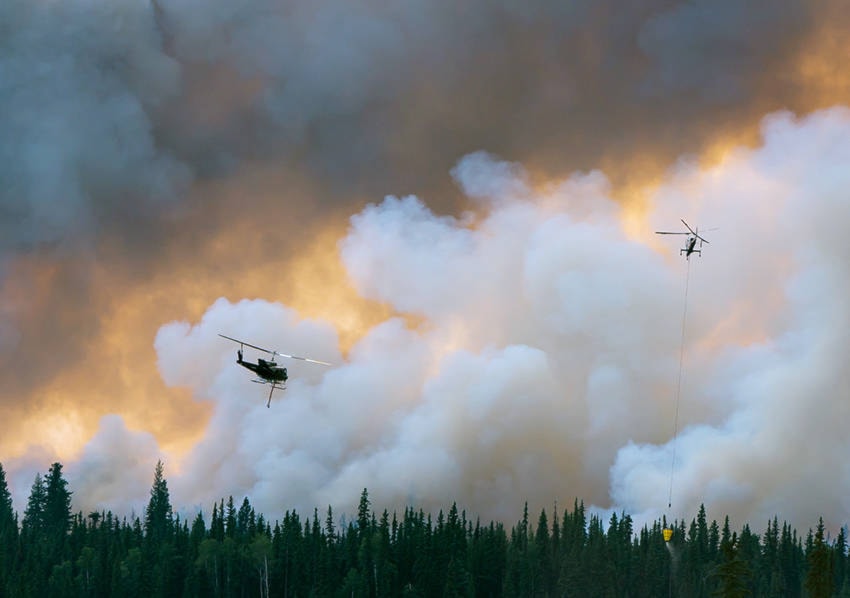
According to the latest BC Wildfire update, there are 82 firefighters, 14 helicopters, 53 pieces of heavy equipment and 22 structural protection personnel working in the 100 Mile Northeast Fire Complex.
Update: The Flat Lake fire is now listed at 26,191 hectares, following more accurate mapping with an aerial track completed before noon Tuesday.
The new measurement does not include any of today’s controlled ignitions, but does include Monday’s growth to the north and west. The controlled burns took place Tuesday afternoon as planned, with a noticeable increase of smoke in surrounding communities.
Update: BC Wildfire Service will conduct controlled ignitions this afternoon, according to an update at 2:40 p.m. Tuesday.
The planned burns will take place north of Cunningham Creek and west of and along the wooden transmission lines. Officials warn that smoke will be visible from Highway 97 and surrounding communities.
Original:
The Flat Lake fire has been officially mapped at 19,247 hectares, but wildfire officials note additional growth has been observed since the most recent measurement Monday morning.
“There was some growth to the north and to the west, and that 19,000 doesn’t include that growth that took place in the afternoon and evening (Monday),” Rosalie MacAulay, information officer with BC Wildfire Service said Tuesday morning.
MacAulay noted that the MODIS Active Fire Mapping posts - which use satellite heat tracking - circulating on social media and purportedly showing the fire’s size and growth should be used “with caution” due to possible inaccuracies with the data.
“Sometimes the smoke itself can radiate heat, and (the maps) will pick up the heat from the smoke,” she said. “If the smoke is drifting beyond the perimeter of the actual fire activity, that’s when we will see something that isn’t accurate.”
Yesterday, crews undertook a successful controlled burn on the southeast flank of the fire, MacAulay confirmed.
“This removes the fuels up to and against the guard line that was already established,” she said. “It establishes an anchor point, which allows the crews and equipment to safely work northward up the east flank.”
MacAulay said there was no controlled burning taking place on the north flank but that crews are “always looking at opportunities” for planned ignitions if the conditions allow.
Crews today plan to continue the guard line along the east flank - between the fire and Highway 97 approximately three kilometres away - and work at helping to secure any properties in the area.
BC Wildfire has 62 firefighters and 53 pieces of heavy equipment working on the Flat Lake fire as of Tuesday, with an additional 22 structure protection personnel deployed to the Northeast Wildfire Complex, which includes Canim Lake, Flat Lake, Succour Lake and Irish Lake.
There are currently 1,074 properties from Flat Lake to Green Lake North, including parts of Lone Butte, under evacuation order. The District of 100 Mile House, Horse Lake and Sheridan Lake remain on evacuation alert.
melissa.smalley@100milefreepress.net
Like us on Facebook and follow us on Twitter