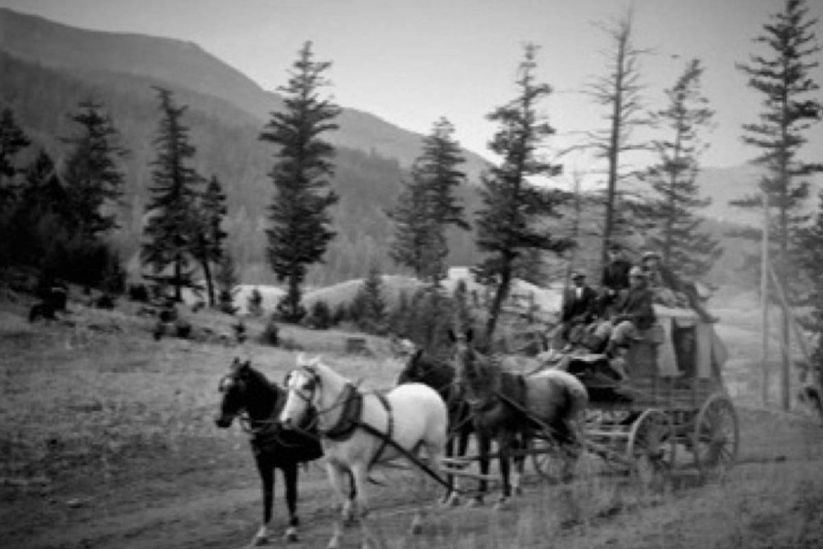
A former Clinton resident thinks he might know where a picture showing a stagecoach on the historic Cariboo Wagon Road was taken.
Last year the New Pathways to Gold Society (NPTGS) received funding for the initial phase of a project to identify, survey, and restore sections of the Wagon Road between Clinton and Lac La Hache, with a technical crew surveying the area to determine authenticity, identify access/permitting issues, and prepare a detailed “restoration prescription” for intact road sections.
READ MORE: Work to begin on restoration of historic Cariboo Wagon Road
As part of the research, Richard Wright of NPTGS has been working with the Clinton Museum to do research, including consulting old photographs, maps, and other documents in an attempt to identify more of the Wagon Road’s original route. To that end, he recently sent the museum a photo taken of the Wagon Road, possibly in the Clinton area, hoping to nail down the precise location.
READ MORE: Clinton locals wanted to look for Cariboo Wagon Road locations
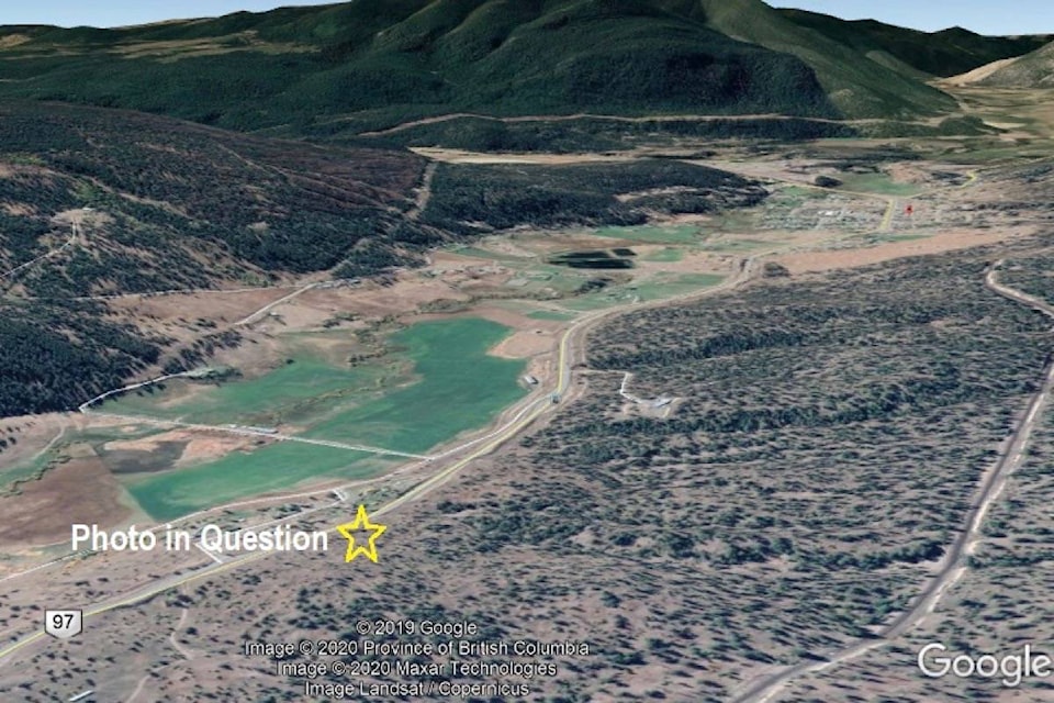
The Journal published the photo in the issue of Jan. 30, 2020, asking if any readers could positively identify the picture as having been taken in the Clinton area and, if so, give a location. David Zant, who grew up in Ashcroft (1970–79) and then moved to Clinton (1980–87), where he finished his schooling at what was then David Stoddart Secondary School, says he believes the picture was taken a few kilometres north of Clinton. The spot is, he thinks, on or near the present-day highway, looking south at approximately latitude 51° 6’ 19.99” N and longitude 121° 33’ 12.94” W on Google Earth.
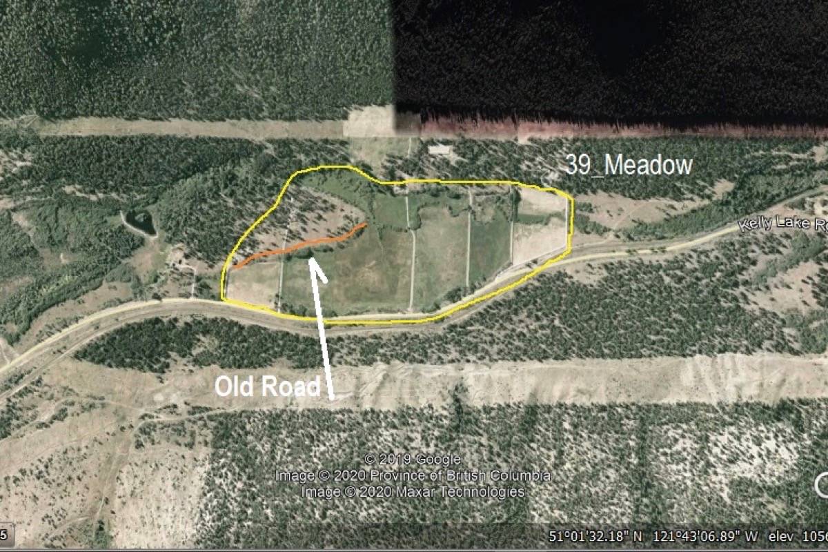
Zant’s parents had a small hobby ranch about 12 kilometres along the Kelly Lake Road (property 1492), and he says that the area was once called “Cut-Off Valley”. A hand-drawn map by Judge Matthew Begbie from 1861 showing trails and roads in the Interior includes the area from Lillooet up the Fraser River to “Big Slide” (now called Kelly Creek), and shows a trail or road from the Fraser through Cutoff Valley and on into Clinton.
“Old-timers mentioned that possibly part of the Wagon Road went through our property,” he writes. “There were remnants of an old road on a side bank I recall, but never knew if this was the original [Wagon Road] or an old skid trail from logging.”
Zant says the story is that the area where he thinks the picture was taken had a natural hay meadow and was called the 39 Meadow. “[It was] a feed stopping area for the wagon trains coming over the mountain from Lillooet [for] feeding/grazing horses and cattle prior to arriving in Clinton for supplies, then proceeding on towards Barkerville.
“If I recall, going back some years, Harry Marriott mentions an area similar to this in an old book he wrote called Cariboo Cowboy. This may be a long shot, and best of luck.”
Anyone with information about the photo and/or Zant’s tentative identification can contact the Journal at editorial@accjournal.ca or the Clinton Museum at info@clintonmuseumbc.org.
editorial@accjournal.ca
Like us on Facebook and follow us on Twitter